Gydlavar dhe Lergh: Rosmeurgi ha Porthmeur
Trail Guide: Rosemergy and Porthmeor
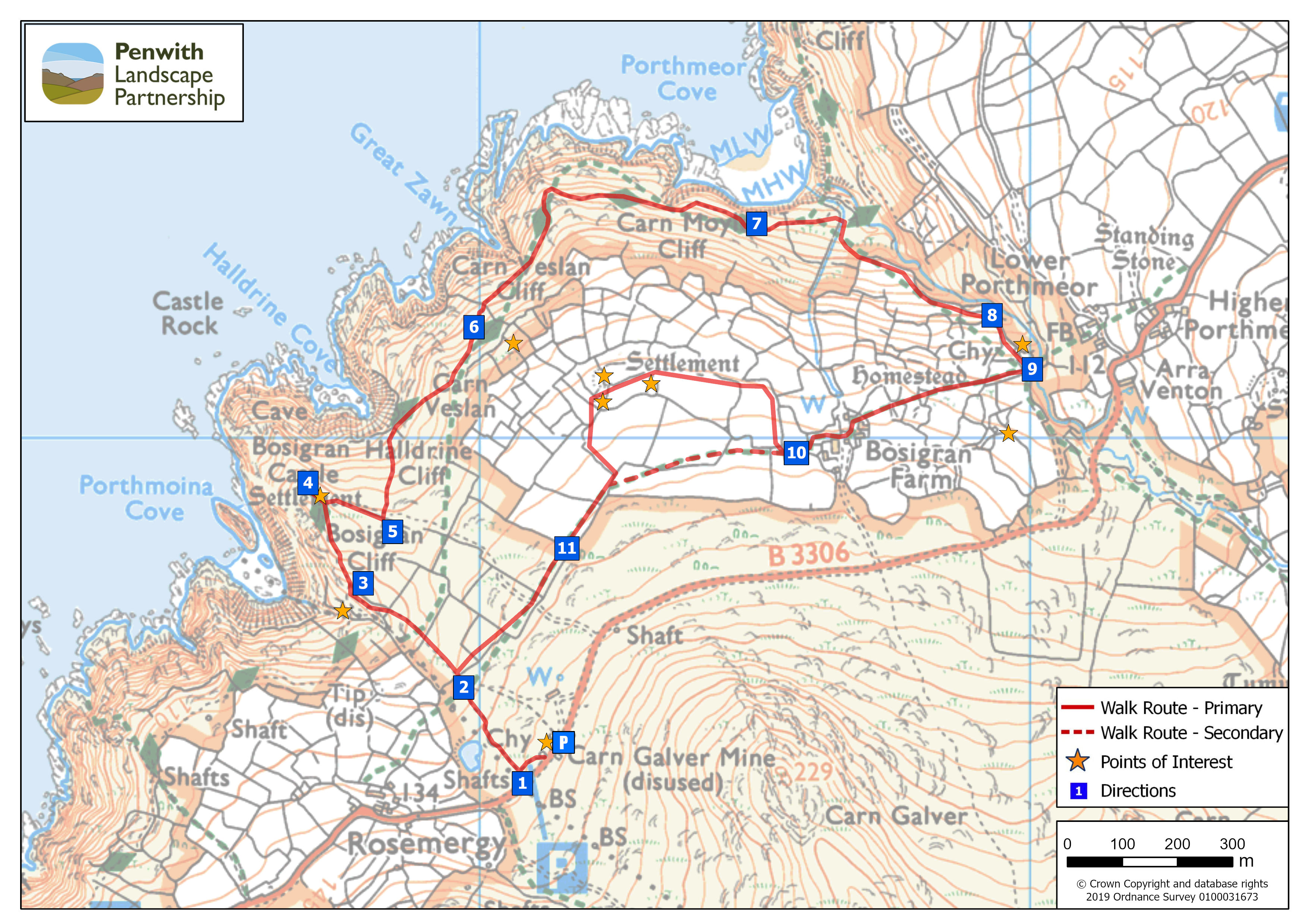
One of the most spectacular stretches of the Penwith coastline. Habitats ranging from cliffs to a lush valley and working farmland. Featuring Bosigran Cliff Castle, Porthmeor Stamps, ancient field systems and the Bosigran Courtyard Houses. Some hedges here are the oldest human-made structures still used for their original purpose in Europe!
The majority of this trail is on National Trust land.
|
Distance: |
2.8 miles / 4.5km |
|
Time: |
Allow three hours |
|
Starting grid reference: |
SW 421 364 |
|
Public Transport: |
First Kernow ‘Land’s End Coaster’ bus (Penzance-Land's End-St Ives) and Transport for Cornwall bus 16a will stop here. |
|
Car Parking: |
At start point - National Trust Car Park at Carn Galva Mine |
|
Nearest Facilities |
Gurnards Head Hotel, Treen. Rosemergy Cream Teas. Morvah Tea Rooms |
| Accessibility & Terrain info: |
The route is steep and very uneven in places, with the occasional stone stile, but if you time it right, you can cool off your feet at the beach! |
|
Safety info & disclaimer: |
See here |
|
Downloadable PDF: |
See here |

Route Instructions:
1. |
Start at the car park. Looking towards the sea, take the grassy path to the immediate left of the mine buildings, down through the willows |
This a popular spot for climbers and the car park is often quite busy. The two engine houses of Carn Galva Mine were built in the 1850s and active up to 1875 when the mine closed. The engine houses were consolidated by the National Trust in the 1980s. The eastern house contained the whim engine, for hauling materials to the surface. It is the better preserved of the two, but is missing its chimney stack (the stump of which can be seen on the adjacent boiler house, recycled from an earlier house on the same site). Only the eastern gable and the chimney stack survive intact on the western house, which contained the pumping engine, pumping water from a shaft some way to the west.
|
|
2. |
Go over the stone stile to the right of the classic iron Penwith Gate, heading downhill towards the sea. Stay along the lower left hand edge of the fields - ignore the paths branching uphill to the right - in the second field head for the bottom corner and cross another granite stile beside a Penwith Gate.
|
The first of the ancient Cornish hedges can be seen on the left side of the valley here surrounding the present-day settlement at Rosemergy. Distinguished by their irregular shape and small size of the fields they enclose, the Rosemergy field system is a fine example of an Iron Age radial field system. There are no extant traces of an associated courtyard house settlement, but the small, oddly shaped enclosures 200m west of the current settlement were almost certainly courtyard house remains. |
|
3. |
Here the path goes up to your right towards the rocky outcrop, past a National Trust stone saying Bosigran. | Below the path on the left are the well-preserved remains of the Porthmoina stamping mill. | |
4. |
As you reach the top here, the ground suddenly levels out and you find yourself in the interior of Bosigran Castle. On a sunny calm day, there is plenty of room for a picnic with staggering views down the coast to Pendeen Watch (lighthouse) and up to Gurnard’s Head. If, as is more likely, the weather is windy and cloudy take great care up here - it's about 700 feet down! A second path heads back inland back away from the cliff castle, heading east - beside a long, low stone wall. |
Bosigran Castle is a simple fortification on a spectacular promontory. Possibly a relatively 'low status' cliff castle compared with Gurnard's Head just up the coast. Other than the cliffs, it is defended by a crude drystone wall across the landward side. There are no traces of internal occupation, suggesting use as an occasional refuge rather than permanent habitation. There is a Logan Stone (rocking stone) within the interior of the castle - fun to find and even more fun to rock on it! The cliffs here on both sides of Porthmoina Cove are popular with climbers.
|
|
5. |
At the bottom of the path beside the wall, you will come across a stone Coastal Path marker - turn left over the wall and follow the coast path as it skirts above Halldrine Cove. The path drops down a little way before climbing up towards Carn Veslan. |
The path passes just beneath the outer fields of Bosigran - these small plots, defined by heavy stony lynchets, were not reused by later farmers and so are remarkably well-preserved. This is one of the most ancient prehistoric field systems in West Cornwall - recently confirmed as dating to the middle Bronze Age (second millennium BC).
|
|
6. |
Continue to follow the coast path above Carn Veslan Cliff, around Carn Moyle, and down towards Porthmeor Cove. |
Soon after the path levels out past Carn Veslan, is a real treat for any botanists on this walk. The National Trust have put in stepping stones to aid walking across a patch of wet ground. An amazing patch about 10 sqm, packed with over 30 species of wildflowers, grasses, rushes, moss, shrubs and sedges, including Cotton grass, Early purple orchid, Jointed rush, Crested dog’s tail……incredible!
|
|
7. |
Go over a wooden stile and make your way across a boulder strewn field, where the path becomes quite fragmented for a short while. Keep going ahead - the way soon becomes more obvious again, then crosses a small stream. Immediately after the stream is a junction. Take the right hand path, which starts to climb up the southern side of the valley towards the Porthmeor Tin Stamps.
|
The left hand path is the continuation of the coast path, and the way to get down to the beach. As you go up the valley, you can hear the rush of an amount of water under the willow and scrub - and you begin to see signs of the industry that once made use of it. |
|
8. |
The path passes through a granite gateway into the site of the stamping mill, and continues as a hedged trackway past the mill. There are a couple of routes off to the left here into the site itself. |
The extensive and well-preserved Porthmeor Tin Stamping Mill was established in 1861 following abandonment of the Porthmoina Stamps (on the other side of Bosigran) due to insufficient water flow; the Porthmeor stream is longer and stronger than Porthmoina. The stamping mill at Porthmeor was built on top of a much older corn and grist mill, that was first recorded in 1627.
|
|
9. |
Just above the mill, you come to a 4-way junction of paths. The track you are on (which continues uphill to the road), is crossed by the Zennor Church Path. Take the path heading right, over the granite stile, which climbs uphill towards Bosigran Farm. The first section of this path has a deep stone ditch on one side. Follow the footpath to reach the stile leading into Bosigran Farmyard - the footpath heads through the farmyard, round to the right and out into the fields on the far side.
|
The stone ditch collected water coming off the fields above, and fed it under the path into a small reservoir in the corner of the field. It has a feed into the mill, to provide water for use on the dressing floors. The Bosigran hamlet, as it is today, was first recorded in 1333, in a different location than the original courtyard houses.
|
|
10. |
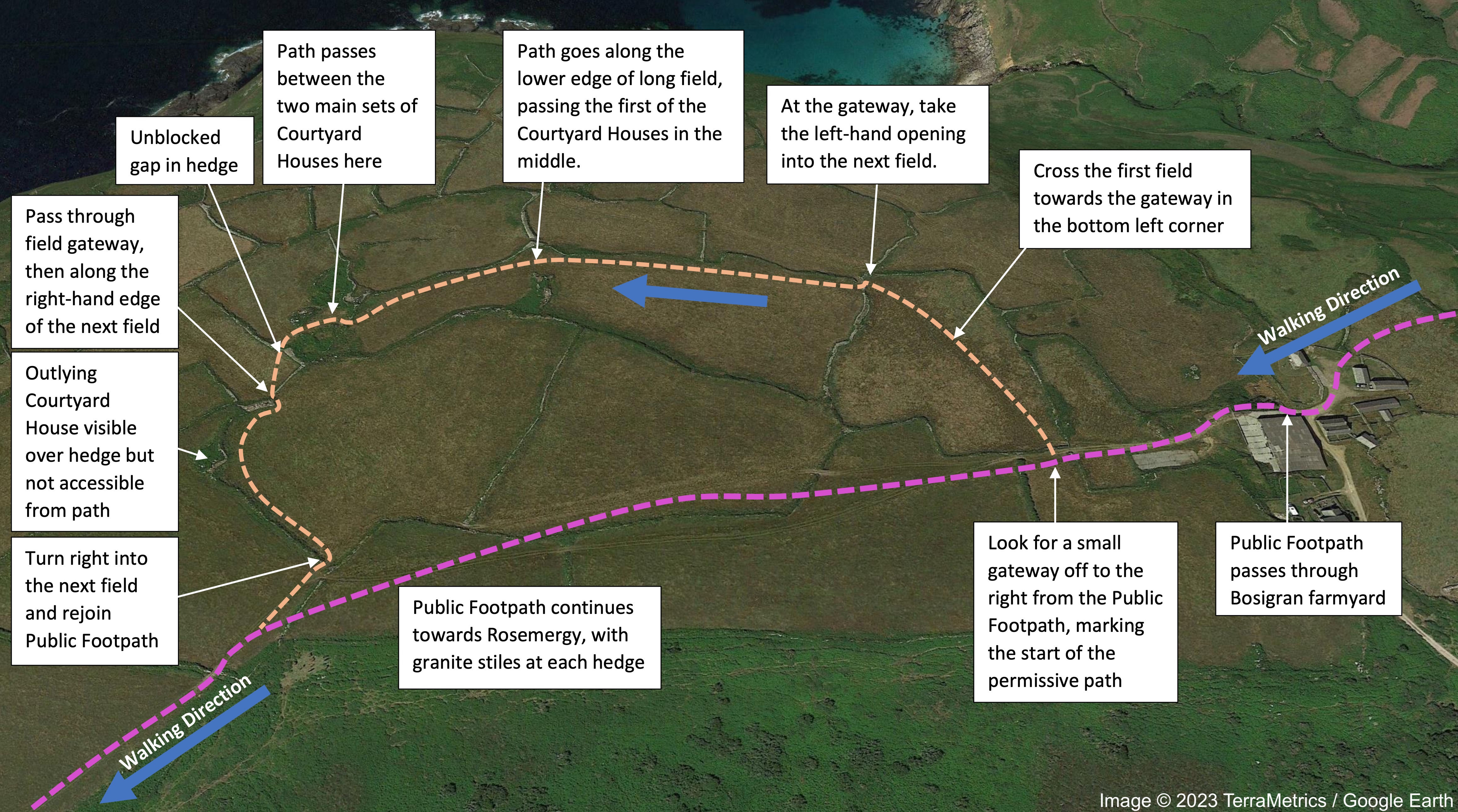
Permissive footpath to Bosigran Courtyard Houses:
|
||
|
|
Notice how these meadows are flat - in between the rough ground around Carn Galva and the cliffs - ideal for farming. This is a Romano-British courtyard house settlement, (dating to the 1st century CE) within a contemporary radial field system, made up of four widely separated courtyard houses and possible roundhouse. This is a fantastic example of a courtyard house settlement, and you can clearly see how these courtyard houses would have developed from earlier roundhouses. In 2022, PLP and the National Trust established a permissive footpath route to the courtyard houses, as a spur off the existing public footpath. An old, long-blocked gap in the hedge next to the courtyard houses was re-opened to facilitate the route - allowing the public to legitimately access the courtyard houses for the first time. |
||
11. |
From the gate indicating the end of the Bosigran fields, the path becomes slightly ambiguous. Take a more obvious path line slightly downhill, ultimately coming the Penwith gate at point 2 – from there follow the path back uphill to the Carn Galva Engine Houses and the start point. |
The right of way line is either long-lost (through an area with shafts and another completely waterlogged, with no evidence of old gaps or stiles), or incorrectly mapped! |
|


